Overview of the Valleys 100 Route
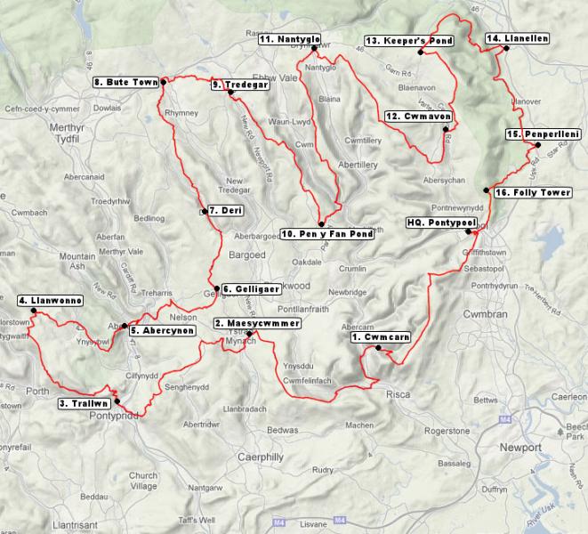
The route starts from West Monmouth Comprehensive School in Pontypool and follows a clockwise route that initially takes you to the summit of Mynydd Maen. A beautiful stretch of moorland walking brings the route to Twmbarlwm, considered by many to be one of the finest viewpoints in Southern Wales. A descent then to Cwmcarn and the route enters the lower Ebbw Valley. The route crosses into the Sirhowy Valley and then climbs to Mynydd y Grug.
From here the route descends to Maesycwmmer and crosses the lower Rhymney valley before climbing to Mynydd and Cefn Eglwysilan. Here you will be treated to a bird’s eye view of the Taff Valley that the route soon crosses. The route descends to Pontypridd and then follows the easternmost ridge of the famous Rhondda valleys, providing what we hope will be glorious views in late afternoon light.
From Llanwonno the route descends to Ynysbwyl and Abercynon and the first night section follows the Rhymney Valley Ridgeway through Gelligaer to Deri via common land and a disused railway line. The path climbs the shoulder of Cefn Brithdir and follows the Rhymney Valley Ridgeway to its northern terminus. A walk through Bryn Bach Park brings the route to the breakfast stop in Tredegar.
Following a sustaining breakfast, the route crosses the upper Sirhowy Valley and climbs to Cefn Manmoel. The route provides a bird’s eye view over the upper Ebbw Valley as it goes south to the Pen y Fan pond. Now the route enters the Ebbw valley and climbs to Mynydd Carn y Cefn. We consider this ridge to be one of the nicest in South Wales and the Brecon Beacon peaks of Corn Du and Pen y Fan dominate the views to the north.
The route descends to Nantyglo and then climbs the Coity Mountain. A wide grassy track is gently climbed as it goes south before a gentle descent to the next checkpoint at Cwmavon is enjoyed. From Cwmavon, a steady ascent of Mynydd-y-garn-fawr takes place to the visually spectacular checkpoint at Keeper’s Pond that is situated on the shoulder of the Blorenge Mountain.
Now the route follows what many will consider to be a visual highlight with views across the Usk Valley towards the Black Mountains as the path skirts around the northern side of the Blorenge. A very gentle descent takes the route to Llanellen via the Punchbowl, a lake on the side of the hill. The route then follows the Monmouthshire and Brecon Canal to the village of Goytre. Finally, the route climbs back to a ridge to provide a farewell view of the eastern valleys and descends to the finish at Pontypool.